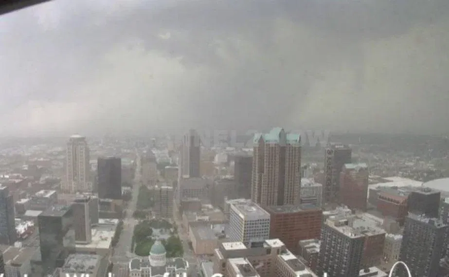
ST. LOUIS, Mo. — In a harrowing development that underscores the volatility of spring weather patterns in the American Midwest, the National Weather Service (NWS) has confirmed a large and dangerous tornado touchdown in the Clayton area of St. Louis County. This alarming event has prompted immediate and widespread concern across the greater St. Louis metropolitan region, including critical alerts for St. Louis City, St. Louis County, and portions of the Metro East, notably Granite City and Madison County.
The tornado, described by meteorologists as both large and extremely dangerous, is moving eastward with significant velocity and unpredictability, thereby elevating the urgency of all advisories and triggering a cascade of safety protocols and emergency responses. At the heart of the warnings issued is a Tornado Warning currently in effect through 3:15 p.m. Friday for the aforementioned regions. Residents within these zones have been emphatically urged to seek immediate shelter, especially given the life-threatening nature of the storm.
Background: Tornado Activity in the Heartland
Tornadoes are not foreign phenomena in Missouri and Illinois. Situated within what meteorologists often refer to as “Tornado Alley,” the St. Louis metro area has historically been susceptible to severe weather outbreaks, particularly in spring and early summer. Missouri alone averages around 30 to 45 tornadoes annually, while Illinois typically sees about 50. Some of the most catastrophic tornadoes in American history have occurred in these states, including the Tri-State Tornado of 1925 and the more recent Joplin tornado of 2011, which claimed 158 lives.
The current storm system impacting the St. Louis area originated from a potent atmospheric disturbance sweeping eastward across the central United States. Meteorologists attribute this disturbance to a deep low-pressure system interacting with unseasonably warm and moist air masses from the Gulf of Mexico, creating an ideal environment for the development of supercells — the type of thunderstorm most commonly associated with tornado formation.
Meteorological Outlook and Regional Impact
This particular system has garnered heightened attention due to its capacity for producing not just tornadoes but also extremely large hail and damaging wind gusts. A Weather Impact Alert has been declared for the entirety of Friday afternoon, particularly during the hours of 1 p.m. to 7 p.m., when conditions are forecasted to be most volatile. Within this critical window, meteorologists warn that storms could produce baseball-sized hail and winds exceeding 70 mph, capable of inflicting substantial structural damage and creating widespread power outages.
In a significant and telling move, the Storm Prediction Center (SPC) upgraded its severe weather risk assessment for the St. Louis metro area to a Level 4 out of 5 on its severity scale. This classification, known as a Moderate Risk, represents one of the highest levels of alert short of a High Risk designation. It reflects a confluence of atmospheric conditions highly favorable for organized, long-lived, and particularly dangerous storm systems. The SPC’s decision to elevate this risk level was announced Thursday afternoon, signifying an increased level of confidence among meteorologists in the potential for widespread severe weather outbreaks.
Although southeastern Missouri and parts of southern Illinois are expected to bear the brunt of the most intense activity, the nature of the system is such that no part of the region can be considered immune. Forecasters emphasize that even areas northwest of St. Louis could experience dangerous weather due to rapidly evolving conditions and the potential for storm cell mergers.
Localized Alerts and Affected Communities
Beyond the immediate St. Louis metro area, additional tornado warnings have been issued for nearby locales, underscoring the wide-reaching impact of this severe weather system. St. James and Crawford County are under warning through 2:30 p.m., while Rolla and surrounding communities were previously under alert until 2:00 p.m. These overlapping warnings demonstrate how quickly tornado activity can develop and shift, complicating efforts for emergency management and public safety.
In Madison County and Granite City — densely populated areas within the Metro East region of Illinois — residents have been directed to shelter immediately, particularly in light of the storm’s eastward trajectory. Emergency management agencies in both cities have activated response protocols and are coordinating with state and federal authorities to monitor developments and deploy resources as needed.
Public Safety Measures and Emergency Response
The NWS and local officials have issued an urgent plea for all residents in affected areas to adhere strictly to tornado safety guidelines. These include moving to a basement or interior room on the lowest floor of a sturdy building, staying away from windows and exterior walls, and having an emergency plan in place. For those caught outdoors or in vehicles, the advice is to seek shelter in a sturdy building or, if no shelter is available, to lie flat in a low-lying area away from vehicles and trees.
Authorities stress that tornado sirens may sound with little warning, and that the situation could evolve rapidly as the storm system interacts with local atmospheric conditions. Real-time updates are available through local news channels, NOAA weather radio, and reputable weather apps. Schools, businesses, and public institutions throughout the region are enacting shelter-in-place protocols as they await further developments.
Historical Context: Tornadoes in the St. Louis Region
The greater St. Louis area has a long and sobering history with tornadoes. One of the most destructive tornadoes to strike the city occurred on May 27, 1896, claiming the lives of at least 255 people and injuring over a thousand. The storm caused an estimated $10 million in damages at the time — equivalent to nearly $330 million today. More recently, the 2011 Good Friday tornado caused extensive damage to Lambert-St. Louis International Airport, forcing its temporary closure and highlighting vulnerabilities in critical infrastructure.
This historical backdrop adds a layer of urgency and gravity to the current warnings. Emergency management agencies have learned from past disasters and have improved communication channels, implemented early-warning systems, and invested in community education efforts to better prepare the public for events like the one unfolding today.
Scientific Analysis and Expert Opinions
Meteorologists and climatologists are closely analyzing the atmospheric dynamics at play in this event. Dr. Karen Mitchell, a senior atmospheric scientist at the University of Missouri, noted that the convergence of high moisture content, strong wind shear, and elevated instability levels created a “textbook scenario” for tornadic activity.
“This is exactly the kind of setup we worry about in spring,” Dr. Mitchell said. “The jet stream is active, the ground is warming rapidly, and any disturbance can become a supercell very quickly. The fact that the SPC upgraded the risk to Level 4 tells us just how dangerous this system is.”
Other experts emphasize the role of climate change in potentially increasing the frequency and severity of such storms. While it remains a subject of ongoing research, several peer-reviewed studies suggest that warmer global temperatures may be contributing to more frequent and intense convective storms, particularly in the Midwest and Southeast.
Preparedness and Community Response
As of early Friday afternoon, shelters across St. Louis County and surrounding regions have opened their doors to residents seeking refuge. Churches, schools, and community centers have transformed into emergency hubs, staffed by volunteers and first responders trained in disaster management. Utility companies are on high alert, preparing to dispatch crews in response to downed power lines and other infrastructure failures.
In Granite City, Mayor Mike Parkinson issued a statement urging residents to remain calm but vigilant. “We are taking every precaution and coordinating closely with county and state agencies. Our first priority is the safety of our residents. Please do not take this situation lightly.”
Implications for the Future
Beyond the immediate danger, today’s tornado event raises broader questions about infrastructure resilience, emergency preparedness, and public awareness. As urban development continues to expand into previously rural areas, the risk posed by severe weather increases. Experts call for improved building codes, enhanced meteorological funding, and more robust community outreach programs to ensure that the public is not only informed but also empowered to act.
As the tornado continues its eastward path, the coming hours will be critical in assessing the full extent of the damage and the effectiveness of preparedness measures. In the meantime, the people of St. Louis, Clayton, Granite City, and Madison County must remain resolute, relying on both modern technology and communal solidarity to weather yet another challenge from the forces of nature.
Real-Time Monitoring and Next Steps
Residents are strongly encouraged to keep multiple sources of information at hand. This includes battery-powered weather radios, mobile apps with severe weather alerts, and direct communications from local emergency management offices. As of the latest updates, the Tornado Warning remains in effect until 3:15 p.m., but forecasters caution that additional warnings may follow depending on how the storm develops.
For now, the entire region holds its breath, bracing for impact and hoping that swift action and widespread vigilance will spare lives and limit destruction. The unfolding situation serves as a sobering reminder of nature’s power and the importance of preparedness in an increasingly unpredictable world.
Leave a Reply